- 세계
- »
- PH
- »
- 칼라바르손 지방
- »
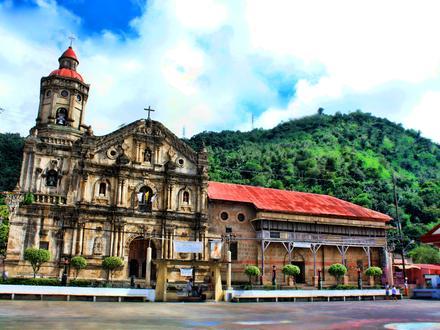
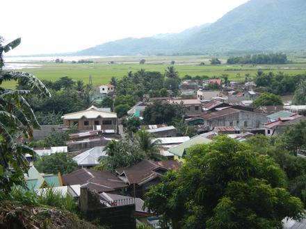
- Pangil, 칼라바르손 지방
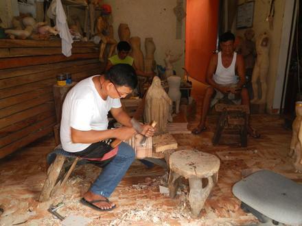
Pangil에 있는 회사
산업
산업별 사업 분포 레스토랑: 17.3%
쇼핑: 12.8%
호텔 & 여행: 11.6%
교육: 9%
산업: 7.3%
종교: 7.3%
음식: 6.3%
기타: 28.4%
| Pangil, 칼라바르손 지방의 면적 | 45km² |
| 인구 | 26,876 |
| 남성 인구 | 13,700 (51%) |
| 여성 인구 | 13,176 (49%) |
| 1975부터 2015까지의 인구 변화 | +158.3% |
| 2000부터 2015까지의 인구 변화 | +5.6% |
| 연령 중앙값 | 23.5 |
| 남성 연령 중앙값 | 23 |
| 여성 연령 중앙값 | 24.1 |
| 주민 | Sulib |
| 현지 시간 | 일요일 PM 1:47 |
| 시간대 | 필리핀 표준시 |
| 위도 및 경도 | 14.4033° / 121.46506° |
| 우편 번호 | 4018 |
Pangil, 칼라바르손 지방 - 지도
Pangil, 칼라바르손 지방 인구
1975년부터 2015년까지| 데이터 | 1975 | 1990 | 2000 | 2015 |
|---|---|---|---|---|
| 인구 | 10,405 | 20,766 | 25,456 | 26,876 |
| 인구 밀도 | 231.1 / km² | 461.2 / km² | 565.3 / km² | 596.8 / km² |
2000부터 2015까지의 Pangil 인구 변화
2000년부터 2015년까지 5.6% 증가| 위치 | 1975 이후의 변화 | 1990 이후의 변화 | 2000 이후의 변화 |
|---|---|---|---|
| Pangil, 칼라바르손 지방 | +158.3% | +29.4% | +5.6% |
| 라구나 주 | +521.6% | +129.2% | +52.1% |
| 필리핀 | +146.5% | +63.3% | +29.5% |
Pangil, 칼라바르손 지방 연령 중앙값
연령 중앙값: 23.5년| 위치 | 연령 중앙값 | 평균 연령 (여성) | 중간 나이 (남) |
|---|---|---|---|
| Pangil, 칼라바르손 지방 | 23.5년 | 24.1년 | 23년 |
| 라구나 주 | 24.8년 | 25.3년 | 24.2년 |
| 필리핀 | 23.2년 | 23.6년 | 22.8년 |
Pangil, 칼라바르손 지방 인구 계통도
연령과 성별에 따른 인구| 나이 | 남성 | 여성 | 합계 |
|---|---|---|---|
| 5 세 미만 | 1,528 | 1,389 | 2,918 |
| 5-9 | 1,555 | 1,406 | 2,962 |
| 10-14 | 1,578 | 1,430 | 3,008 |
| 15-19 | 1,430 | 1,329 | 2,759 |
| 20-24 | 1,256 | 1,253 | 2,510 |
| 25-29 | 1,108 | 997 | 2,106 |
| 30-34 | 979 | 984 | 1,964 |
| 35-39 | 788 | 814 | 1,603 |
| 40-44 | 855 | 833 | 1,688 |
| 45-49 | 700 | 694 | 1,394 |
| 50-54 | 651 | 612 | 1,263 |
| 55-59 | 452 | 507 | 959 |
| 60-64 | 339 | 330 | 670 |
| 65-69 | 230 | 257 | 488 |
| 70-74 | 159 | 199 | 359 |
| 75-79 | 91 | 142 | 234 |
| 80-84 | 0 | 0 | 0 |
| 85 플러스 | 0 | 0 | 0 |
Pangil, 칼라바르손 지방 인구 밀도
인구 밀도: 596.8 / km²| 위치 | 인구 | 지역 | 인구 밀도 |
|---|---|---|---|
| Pangil, 칼라바르손 지방 | 26,876 | 45km² | 596.8 / km² |
| 라구나 주 | 3.2 백만 | 2,664.8km² | 1,191 / km² |
| 필리핀 | 96.6 백만 | 296,939.4km² | 325.3 / km² |
Pangil, 칼라바르손 지방 과거 및 예상 인구
1700부터 2100까지의 추정 인구Sources:
1. JRC (European Commission's Joint Research Centre) work on the GHS built-up grid
2. CIESIN (Center for International Earth Science Information Network)
3. [링크] Klein Goldewijk, K., Beusen, A., Doelman, J., and Stehfest, E.: Anthropogenic land use estimates for the Holocene – HYDE 3.2, Earth Syst. Sci. Data, 9, 927–953, https://doi.org/10.5194/essd-9-927-2017, 2017.
주민
Pangil의 지역별 사업체 분포 Sulib: 36.4%
Natividad: 18.2%
Barangay Natividad (Pob.): 18.2%
Isla: 9.1%
Dambo: 9.1%
Isla (Pob.): 9.1%
지역 코드
Pangil에 있는 사업체가 사용하는 지역 번호 비율 지역번호 49: 52.6%
지역번호 916: 10.5%
지역번호 919: 10.5%
지역번호 93: 10.5%
지역번호 2: 5.3%
지역번호 917: 5.3%
지역번호 921: 5.3%
인간 개발 지수 (HDI)
평균 수명, 교육 및 일인당 소득의 통계 복합 지수.Sources: [Link] Kummu, M., Taka, M. & Guillaume, J. Gridded global datasets for Gross Domestic Product and Human Development Index over 1990–2015. Sci Data 5, 180004 (2018) doi:10.1038/sdata.2018.4
Pangil, 칼라바르손 지방 CO2 배출량
일인당 연간 이산화탄소 배출량 (CO2)| 위치 | 이산화탄소 배출 | 일인당 이산화탄소 배출량 | 이산화탄소 배출 강도 |
|---|---|---|---|
| Pangil, 칼라바르손 지방 | 41,635tn | 1.55tn | 924.6 tn/km² |
| 라구나 주 | 4,994,521tn | 1.57tn | 1,874 tn/km² |
| 필리핀 | 104,920,564tn | 1.09tn | 353.3 tn/km² |
Pangil, 칼라바르손 지방 CO2 배출량
| 2013 CO2 배출량(톤/년) | 41,635tn |
| 1인당 2013 CO2 배출량(톤/년) | 1.55tn |
| 2013 CO2 배출 정도(톤/km²/년) | 924.6 tn/km² |
자연 재해 위험
10 개 중 상대 위험| 산사태 | 높음(8) |
| 집진 장치 | 높음(10) |
| 가뭄 | 보통(4) |
| 홍수 | 높음(10) |
| 지진 | 높음(8) |
* 특히 홍수 나 산사태와 관련된 위험은 전체 지역에 해당되지 않을 수 있습니다.
Sources: 1. Dilley, M., R.S. Chen, U. Deichmann, A.L. Lerner-Lam, M. Arnold, J. Agwe, P. Buys, O. Kjekstad, B. Lyon, and G. Yetman. 2005. Natural Disaster Hotspots: A Global Risk Analysis. Washington, D.C.: World Bank. https://doi.org/10.1596/0-8213-5930-4.
2. Center for Hazards and Risk Research - CHRR - Columbia University, Center for International Earth Science Information Network - CIESIN - Columbia University. 2005. Global Flood Hazard Frequency and Distribution. Palisades, NY: NASA Socioeconomic Data and Applications Center (SEDAC). https://doi.org/10.7927/H4668B3D.
3. Center for Hazards and Risk Research - CHRR - Columbia University, Center for International Earth Science Information Network - CIESIN - Columbia University, and Norwegian Geotechnical Institute - NGI. 2005. Global Landslide Hazard Distribution. Palisades, NY: NASA Socioeconomic Data and Applications Center (SEDAC). https://doi.org/10.7927/H4P848VZ.
4. Center for Hazards and Risk Research - CHRR - Columbia University, Center for International Earth Science Information Network - CIESIN - Columbia University, and International Research Institute for Climate and Society - IRI - Columbia University. 2005. Global Drought Hazard Frequency and Distribution. Palisades, NY: NASA Socioeconomic Data and Applications Center (SEDAC). https://doi.org/10.7927/H4VX0DFT.
5. Center for Hazards and Risk Research - CHRR - Columbia University, Center for International Earth Science Information Network - CIESIN - Columbia University, International Bank for Reconstruction and Development - The World Bank, and United Nations Environment Programme Global Resource Information Database Geneva - UNEP/GRID-Geneva. 2005. Global Cyclone Hazard Frequency and Distribution. Palisades, NY: NASA Socioeconomic Data and Applications Center (SEDAC). https://doi.org/10.7927/H4CZ353K.
6. Center for Hazards and Risk Research - CHRR - Columbia University, Center for International Earth Science Information Network - CIESIN - Columbia University. 2005. Global Earthquake Hazard Distribution - Peak Ground Acceleration. Palisades, NY: NASA Socioeconomic Data and Applications Center (SEDAC). https://doi.org/10.7927/H4BZ63ZS.
최근 인근 지진
크기 3.0 이상| 날짜 | 시간 | 크기 | 거리 | 깊이 | 위치 | 링크 |
|---|---|---|---|---|---|---|
| 19. 7. 3. | PM 8:00 | 4.5 | 57.7km | 10,000m | 0km SSE of Montecillo, Philippines | usgs.gov |
| 18. 10. 14. | PM 6:56 | 4.5 | 63.9km | 41,880m | 6km S of Panukulan, Philippines | usgs.gov |
| 18. 7. 5. | PM 2:00 | 4.4 | 55.1km | 35,000m | 21km NNE of Perez, Philippines | usgs.gov |
| 17. 6. 20. | PM 6:18 | 4.3 | 47km | 10,000m | 0km E of San Andres, Philippines | usgs.gov |
| 16. 11. 9. | PM 11:11 | 4.8 | 42.7km | 59,240m | 20km N of Daraitan, Philippines | usgs.gov |
| 16. 2. 2. | AM 5:04 | 4.2 | 63.8km | 119,790m | 1km ESE of Banaybanay, Philippines | usgs.gov |
| 15. 12. 20. | PM 8:46 | 4.4 | 33.3km | 35,000m | 2km ENE of Lucban, Philippines | usgs.gov |
| 15. 8. 24. | AM 11:06 | 4.5 | 47.7km | 35,000m | 1km S of Binan, Philippines | usgs.gov |
| 14. 9. 12. | AM 11:44 | 4.4 | 67.6km | 143,630m | 1km NNW of Balagtasin, Philippines | usgs.gov |
| 12. 10. 30. | PM 7:07 | 4.5 | 56.6km | 35,000m | Luzon, Philippines | usgs.gov |
Pangil, 칼라바르손 지방 인근의 과거 지진 발생 찾기
가장 빠른 날짜 최신 날짜
크기 3.0 이상 크기 4.0 이상 크기 5.0 이상
우리의 데이터
이 페이지의 데이터는 공개적으로 사용 가능한 많은 도구와 리소스를 사용하여 추정됩니다. 보증없이 제공되며 부정확 한 내용이 포함될 수 있습니다. 자신의 책임하에 사용하십시오. 자세한 내용은 여기 를 참조하십시오.